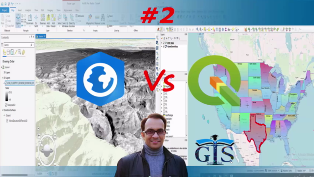
ArcGIS Pro vs QGIS Level 2: Map Editing, Database & Web GIS
Want to Learn Advanced Map Digitizing, Database, Programming & Web GIS by using Both ArcGIS Pro and QGIS?! Then Enroll..
3.50 (2 reviews)

50
students
5 hours
content
Feb 2025
last update
$19.99
regular price
What you will learn
Shapefile Edit and Map Digitizing in ArcGIS Pro and QGIS
Web GIS with ArcGIS Pro
Case Study 1: Identify The Summation of Male and Female Population in Each State of USA
Case Study 2: Identify Latitude/Longitude Value of Each Point Feature and Create a New Field to Input These Values
Case Study 3: Calculate Area of Each Polygon Feature
Case Study 4: Calculate Total Number of Vertices of Each Polygon Feature
Case Study 5: Calculate Total Male and Female Population of Each State
How to Add Pie Chart in Map
ArcGIS Online Account
Web GIS Project with ArcGIS Online
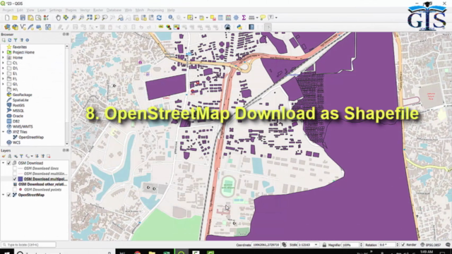
OpenStreetMap Download as Shapefile for a Particular Area in QGIS
Differences Between ArcMap and ArcGIS Pro to Add Field and Edit Field Value
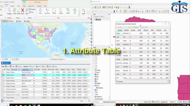
Attribute Table of ArcGIS Pro and QGIS
Code Expression Techniques of Calculate Field Window
Calculate Field
Calculate Geometry
Vertex Tool
How to Add Pie Chart in Each Feature of Layer
Field Alias
Magical Tips to Start Writing Any Code Languages Easily
How to Copy Attribute Rows to Excel File with Field Name as Column Heading
Pop Up Menu of Attribute Table
Label Visibility Tricks
Rule-based Labeling
Trace Tool
Fields View Window
How to Split and Organize More Than One Attribute Tables in Separated Portions of ArcGIS Pro Interface
Attribute Table Editing Mode
Add Row or Feature
Relation Between Row and Map Feature
Dock Attribute Table
Show and Filter Attributes in QGIS
Table View and Form View
Feature Count inside Attribute Table
Field Filter
Highlight Current Feature on Map
Difference Between Field Name and Field Alias
Data Type
Precision and Integer Data Type in QGIS
Difference Between Length and Precision
Difference Between ArcMap Editor and ArcGIS Pro Edit
Tools inside Edit Tab
Right Angle Line Tool
Circle Drawing
Rectangle Drawing
Move Tool
Rotate Feature
Edit Vertices to Reshape Feature
Add or Delete Vertices
Merge
Split
How to Make Layer as Non-Editable Layer
Which Layers are By Default Non-Editable Layer
Point At End of line
Create Point Along Line
Scale Tool
How to Edit Feature in 3D Basemap
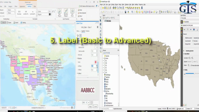
Label Properties of ArcGIS Pro and QGIS
Difference Between Label Properties of Different Types of Features
Label Class
Label Placement
Layer Styling
Layer Diagram Properties
Pie Chart Legend
Font Style
Label Buffer
Label Drop Shadow
Label Shadow Offset
Cartographic Placement
Label Distance
Quadrant Options
European Streets Label Placement
Centered Straight
Street Address Label Placement
Contours Label
Position Offset
Halo for Label
View Unplaced Label
What is Label Visibility
Offset from Centroid
Centroid Options
Offset X, Y
Using Perimeter
Horizontal Placement
Free Placement
Using Perimeter (Curve)
Symbology
Project Tags
Publish Map in ArcGIS Online
OSM Plugins in QGIS
XYZ Tiles
What Types of Features can be Downloaded from OSM
OSM File Format
Layers inside OSM File
Export OSM File to Shapefile by Using QGIS
Screenshots
3350104
udemy ID
7/20/2020
course created date
8/2/2020
course indexed date
Bot
course submited by